source: G M Hopkins Survey Map, Philadelphia, PA, 1887
(solid lines in alleys and leading to 16 St are sewers)
Development
L'Enfant's plan conceived a substantial city, but until the Civil War Washington was more of a southern town. By the 1860 census the population had reached only 75,000. Much of the planned city remained woods, orchards or farms.
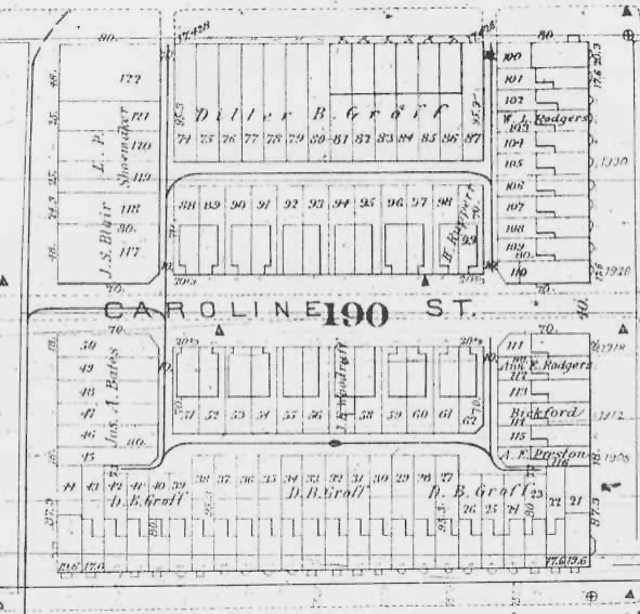
All this changed as the need for housing following the Civil War drove residential development northward.[1] Like many other streets in the neighborhood—Corcoran, Riggs, and Swann to name a few—the creation of Caroline Street created more lots to meet the housing demand. A plat map by G. M. Hopkins for the year 1887 on the following page shows Caroline Street and its new lot configuration. The square number from these early maps and the resultant lot numbers from the 1887 one are still used today to define property locations.
|
|
A careful look at property owners’ names on the 1887 Hopkins plat map indicates that developer Groff was still busy in the neighborhood. He appears as the owner of the entire north side of the 1500 block of T Street and of the south side of U Street. A new alley system is shown serving Caroline and adjacent T and U Streets, as are the footprints of the two styles of houses—indented and flat fronts—that Groff built on the Caroline. The footprints of other nearby houses—planned or in existence—are also shown.
It is not known whether early residents of Caroline Street experienced problems with damp basements or actual water in them during severe rainfall as some current residents have. There was, however, a stream called Slash Run that coursed down the escarpment and crossed the southeast corner of Square 190 on its meandering way to Rock Creek. The unsourced map following page six, provided by current Caroline Street resident Michael Schade, gives an indication of the stream’s path. Unfortunately, Square 190 (located to the left of Square 191) is not clearly shown because the map’s markings that generally indicate marshy areas have not copied well. The fact that the area was marshy, however, suggests a further reason for wet basements over the years.
[Insert Slash Run map here if it will fit]
[1] The population of the City of Washington was 61,122 in 1860, was 109, 199 in 1870, and had grown to 177,624 in 1880. Source: City of Magnificent Intentions, The D.C. History Curriculum Project, Associates for Renewal in Education, Washington, D.C., 1983, p. 71; DC Office of Planning.
Last update 18 May 2004
Copyright Richard Busch, 1993, 2004
Blanket permission for downloading and reproduction for personal use is given.
Any commercial use without explicit written permission is prohibited.
home | previous page - the plan | next page - the street | contact